

 Riecker Chiropractic


LIVE, LOCAL EMERGENCY UPDATES: Severe Thunderstorms Moving Through

[7:30 PM] Lots of photos coming in to the newsroom this evening from listeners across Dubois County. You can see them all here... https://www.witzamfm.com/news/local-storm-damage
-----
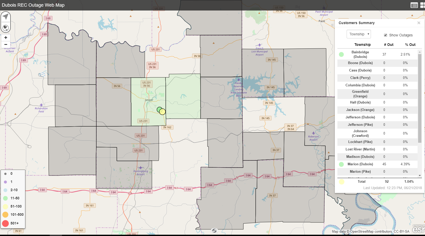
[7:03 PM] There are only a handful of Dubois REC customers without power. Immediately following the storm, around 400 customers were without power.
-----
[4:00 PM] Dubois REC crews have been making progress on restoring power. Currently 84 without power.
-----
[3:15 PM] Currently there are still 116 Dubois REC customers without power from this afternoon's storms. Power is being restored quickly. Just an hour ago there were 411 without power.
-----
[3:00 PM] Severe Thunderstorm Watch has been cancelled. Flash Flood Watch has been placed into effect until 2 AM.
-----
[2:00 PM] CANCELLATION -- All baseball / softball at the Youth Sports Complex is CANCELLED TONIGHT.
-----
[1:34 PM] There are now 411 people without power in Dubois County, according to the Dubois REC outage map.

-----
[1:27 PM] There are around 200 Dubois REC customers without power currently.
[1:11 PM] TORNADO WARNING in effect for SPENCER COUNTY. Severe thunderstorm WARNING for Dubois and Perry Counties through 2:13 P.M.
-----
[12:56 PM] A new Severe Thunderstorm Warning is in effect for Warrick and Gibson Counties. This is a radar indicated threat. Warning through 1:30 pm.
-----
[12:54 PM] Severe Thunderstorm WARNING for Dubois and western Perry County until 1:15 pm. Trees have been uprooted from this line of storms. Expect damage to roofs and siding. For your protection, move to an interior room in the lowest level of your building. Seek shelter now.
-----
[12:50 PM] -- Severe Thunderstorm WARNING in effect for Daviess and Knox Counties. 60 mph winds possible. Trees have been uprooted from this line of storms. Expect damage to roofs and siding.
-----
[12:38 PM] -- Severe Thunderstorm WARNING has been issued for eastern Warrick, Spencer and Pike Counties until 1:45 pm.
-----
[12:25 PM] -- Severe storms are getting closer. There is a history of downed trees with these storms. The saturated ground is increasing the risk for downed trees. Power outages may result.

-----
[12:10 PM] -- The National Weather Service has issued a Severe Thunderstorm Warning for ....
Gibson, IN, Warrick, IN, Vanderburgh, IN, and Henderson, KY beginning at 12:07 pm and ending at 1:07 pm (WITZWQKZ)
-----
[11:30 AM] -- THE NATIONAL WEATHER SERVICE HAS ISSUED SEVERE THUNDERSTORM WATCH
136 IN EFFECT UNTIL 6 PM EDT /5 PM CDT/ THIS EVENING FOR THEFOLLOWING AREAS
IN INDIANA THIS WATCH INCLUDES 10 COUNTIES
IN SOUTH CENTRAL INDIANA
CLARK CRAWFORD DUBOIS
FLOYD HARRISON JEFFERSON
ORANGE PERRY SCOTT
WASHINGTON
IN KENTUCKY THIS WATCH INCLUDES 15 COUNTIES
IN EAST CENTRAL KENTUCKY
ANDERSON
IN NORTH CENTRAL KENTUCKY
BRECKINRIDGE BULLITT HARDIN
HENRY JEFFERSON MEADE
NELSON OLDHAM SHELBY
SPENCER TRIMBLE
IN NORTHWEST KENTUCKY
HANCOCK OHIO
IN SOUTH CENTRAL KENTUCKY
GRAYSON
THIS INCLUDES THE CITIES OF BARDSTOWN, BEDFORD, BRANDENBURG,
CORYDON, ELIZABETHTOWN, ENGLISH, HARDINSBURG, HARTFORD,
HAWESVILLE, JASPER, JEFFERSONVILLE, LA GRANGE, LAWRENCEBURG,
LEITCHFIELD, LEWISPORT, LOUISVILLE, MADISON, NEW ALBANY,
NEW CASTLE, PAOLI, SALEM, SCOTTSBURG, SHELBYVILLE,
SHEPHERDSVILLE, TAYLORSVILLE, AND TELL CITY.